I Flew Drones Before They Were Called Drones
When ‘drone’ was not a word yet
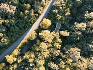
In 2012 I was flying a self-built Unmanned Aerial System — a folding multi-rotor frame carrying a modified Canon camera for automatic serial image capture. The world looks different from above, and I was interested in seeing it.
This was before DJI Phantom. Before “drone” entered everyday language. Building a UAS meant sourcing components, understanding flight controllers, and accepting that if something went wrong, there was no manufacturer to call.
The flight that went sideways
The first test flight with the new folding frame went well — excellent flight behaviour, and the system would become backpack-transportable. The second flight was a load test with the camera mounted.
After about five minutes at 50 metres altitude and 100 metres distance, control was lost. Manual override did not work. GPS-based return-to-home did not work. The platform kept drifting slowly away. Height control still responded — barometric pressure hold was functioning — but lateral control was gone.
Instead of following the UAS on the ground immediately, I wasted time trying to regain control. It drifted towards a wooded valley and disappeared from sight approximately 800 metres away, twenty minutes after takeoff.
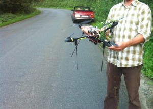
The valley: dense forest, meadows, an abandoned railway line, a small river, and a road with perhaps five cars per hour. The chance of recovery was close to zero. Neither the 5 GHz video downlink nor the autonomous GPS/GSM tracking device — which could have reported the position via SMS — were installed on this frame yet.
Recovery by signal interpolation
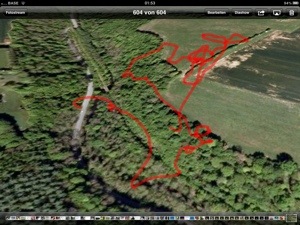
We did the only thing possible: drove into the valley and listened for the telemetry downlink signal. Five minutes in, we picked it up. By driving up and down the road and noting where the signal weakened, we interpolated the midpoint — the point of closest approach to wherever the UAS had come down.
We stopped the car and started planning a systematic search pattern. Ropes for tree recovery. Estimated battery time remaining for telemetry. Then we did something routine: switched off the remote control.
This triggered the loss-of-signal warning beeper on the UAS. And we could hear it. Right there. The platform had come down two metres from the road, in the grass. Not on the road. Not in the trees. Two metres from the tarmac, in a valley full of forest and water.
Minor damage: only one broken boom.
What actually failed
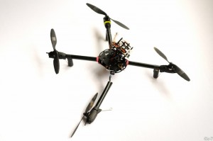
Post-incident analysis: the rubber vibration-dampening studs that mounted the electronics module to the frame had failed. The entire assembly — GPS receiver, gyroscopes, accelerometer — detached and was hanging freely, connected only by power wires to the battery and motors.
This explained everything. GPS return-to-home requires a stable orientation reference — impossible with the module swinging freely. But barometric height hold does not need orientation data, just atmospheric pressure. So the UAS maintained altitude perfectly while drifting laterally without control, until the battery could no longer sustain flight. Then it descended gently into the grass.
A failure mode nobody had designed for. A partial system collapse that was neither total crash nor controlled flight. The kind of thing that only makes sense when you understand every layer of the system.
This incident occurred in August 2012 in the valley near Crupet. Consumer drones as we know them today did not exist — the DJI Phantom launched in January 2013. The UAS was a custom-built folding multi-rotor designed for aerial photography.